Title text:
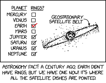
If you don’t know where you are on Earth, the angle of satellite dishes can help constrain your latitude. If some of them are pointing straight up, you’re probably near the Equator, right under the ring.
Transcript:
Transcript will show once it’s been added to explainxkcd.com
Source: xkcd.com/3156/
Pencilnoob@lemmy.world 1 day ago
Hey I am into this! Check out this site I built for tracking satellites!
spacebook.com/explorer
massive_bereavement@fedia.io 1 day ago
It is comforting knowing that our planet is protected by a dense layer of floating garbage. 🫡🚀🗑️
piskertariot@lemmy.world 1 day ago
Your use of the word “dense” there is a little misleading. At the default view the scale of each satelite pixel looks roughly 20km wide.
Cocodapuf@lemmy.world 10 hours ago
Unintentional sick burn on Saturn.
unexposedhazard@discuss.tchncs.de 1 day ago
Whats the difference between the thin green horizontal ring and the wide orange horizontal ring that is slightly tilted?
Image
Pencilnoob@lemmy.world 1 day ago
Green is active, orange is debris or dead sats. When a GEO sat runs out of life / power / fuel the operators are supposed to move it out of the main corridor to make room, so often they are in the same ring but higher or lower
Mensh123@lemmy.world 1 day ago
I’d appreciate if I could use your website without advertisement cookies. Would you mind complying with EU cookie law?
Pencilnoob@lemmy.world 1 day ago
I’m not familiar, what is the law, that we cannot use authentication cookies or google/twitter analytics cookies?
fdnomad@programming.dev 1 day ago
Thats so cool! Looks loke the most popular orbit aligns with the equator. Why is the wider “belt” around that line going over and under? Like
You know what I mean?
sleep_deprived@lemmy.dbzer0.com 1 day ago
Making an educated guess as a layperson, besides some satellites that are geosynchronous but not geostationary, I’d assume those are primarily old geostationary satellites in graveyard orbits - when they’re EOL, satellites in those orbits are supposed to perform a small boost out of them, usually adding a few hundred km to their orbit’s radius (GEO is about 36,000km in altitude, so a few hundred km is relatively small). Then, without station keeping, I believe they should naturally precess around the Laplace plane, which will range between roughly Earth’s equator and the ecliptic plane (the plane of Earth’s orbit). At GEO altitudes the Laplace plane is about 7.2 degrees inclined from the equator. I believe that would mean, starting at the equator with an inclination of 0 degrees, these satellites should precess to about 14.4 degrees and back to 0 over several decades (excluding other perturbations, of course).
I found this online which would seem to confirm at least the mechanics: amostech.com/TechnicalPapers/…/ROSENGREN.pdf
zqwzzle@lemmy.ca 1 day ago
From what I could find that’s probably the band of decommissioned geosynchronous satellites. Apparently they’ll slowly match the orbital plane of the earth around the sun.
…stackexchange.com/…/why-is-the-ribbon-of-decommi…
eager_eagle@lemmy.world 1 day ago
those are mostly red and orange:
Image
BurntWits@sh.itjust.works 20 hours ago
I’ve bookmarked this website. That’s so cool. One of my new favourites now. Thanks for making it.
Pencilnoob@lemmy.world 16 hours ago
Wow thanks! If you like this, on Monday I’m planning to release an update that will let you rewind the viewer all the way back to 1959 and see the first launch of Sputnik. Then let it play forward to today sped up so you can see the growth of satellite counts. Also a new public API to fetch the TLEs from any date. I’m hoping this will let folks do interesting stuff with all that data - maybe AI training or research projects etc.
recklessengagement@lemmy.world 20 hours ago
I browsed for a while and then realized, holy shit, they’re moving. Is this real-time? Either way, this is awesome.
Pencilnoob@lemmy.world 16 hours ago
Yes, so I’m taking every telescope/radio/radar reading I’m allowed to redistribute and then collecting them into a time series database and fetching the most recent reading for each sat into a text file. That’s the TLE download in the public API. Then I use Rust WASM to propagate those readings into positions that are synced with the viewer time. This allows us to very roughly forecast where they will be for the next couple days.
It’s cool because it’s too much data to transfer over the network, so we only transfer the most recent reading and then calculate positions live in the browser.
Vengefu1Tuna@lemmy.zip 21 hours ago
What the fuck, I had no idea we had so many satellites. Also, this site is really cool. Thank you for making this!
Pencilnoob@lemmy.world 16 hours ago
I know it blew my mind too when I first started building this! It’s such a cool project to get to build!
AceBonobo@lemmy.world 1 day ago
Where are the Lagrange points?